Tuesday, August 4, 2009

Grains, Plains, Trains

August 1-2

We are traveling on two-lane Route 2, a flat to only slightly rolling road that parallels railroad tracks and is lined by grain fields for two full days. The monotony of farmland is punctuated by tiny towns with European names—Inverness, Kremlin, Havre, Zurich, Harlem, Glasgow—each with massive grain elevators beside the tracks. The towns were created and named by the Great Northern Railroad in an attempt to lure Northern and Eastern European immigrants to take the train west and homestead in a rail town with a familiar name. The tradition seems to be continuing today, as most of the service workers in the restaurants and shops we visited in Glacier National Park and the feeder towns surrounding it were young Eastern Europeans.

It doesn't take too long for field after field of amber waves of grain to get old,
so the least diversion along the road becomes a cause for excitement. We get a kick out of this espresso teepee in the town of Browning, headquarters of the Blackfoot Indian Reservation. If only we had known that this would be the last espresso stand we would see for hundreds of miles, we might have actually gone in and gotten a latte, instead of just taking a picture of it.


We stop for just about all the historic markers along the highway, and there are many, at least in Montana. One of significance is a stone obelisk marking Camp Disappointment, the furthest north point of Lewis and Clark's westward expedition. They were disappointed that the headwaters of the Marias River did not go north of the 49th parallel, which would have allowed them to claim more land for the United States. They were also disappointed to find a shortage of game, due, they hypothesized, to recent activity by Indian hunters. We are disappointed to find the obelisk commemorating the site covered in graffiti.

We find the massive penguin commemorating Cut Bank, Montana as the "coldest spot in the nation" untouched by vandals (or, perhaps more likely, freshly painted to cover graffiti). The town's claim is based on data collected from the US Weather Service monitoring station here. For the record, it is a balmy 82 degrees at 10:45 a.m. when we blow through town.

We stop beside the road in Saco (pop. 203) to see the one room schoolhouse Chet Huntley attended. The Saco Garden Club moved it from an isolated spot in the countryside to its highly visible spot beside the highway, and planted a nice little garden next to it. It is furnished just as it looked when Chet was a student there, except a tall chain link fence runs across the back of the classroom, so the garden club can leave it open for visitors without too much concern about thievery and vandalism.

We stop for the night in Glasgow ("home of the Scotties"), midway through Montana. On a tip from our hotel, we have dinner at a restaurant in the Elks Club. It is a local secret--the restaurant does not have a sign outside indicating it is open to the public, yet it is full of a festive crowd who all seem to know each other. It reminds us of home, with people greeting friends as they walk through the restaurant, and visiting from table to table. The food and service are surprisingly good, and amazingly inexpensive.
But, it is clear that we have left the land of huckleberry micro-brews, huckleberry pie, and huckleberry ice cream—after a steady daily diet of huckleberries from Washington through Western Montana, we miss them already, almost as much as we miss those espresso stands.


As we leave Glasgow the next morning, we pass four different farm equipment dealers at the edge of town, and a block-long mass of feed and seed elevators trackside. Then, the road runs as a narrow ribbon through grain fields as far as we can see in all directions. There is scarcely a tree in sight for miles and miles and miles. . .

We stop for a moment to commemorate the 10,000th mile of our great summer odyssey. We are on a dirt road south of Route 2, hunting for the town of Epping, North Dakota (pop.75), home of the Buffalo Trails Museum and the Buffalo Inn Café, which our road trip guide has told us are worth the dusty detour, especially on Sunday, when farm families come from miles around for the buffet at the café. It is Sunday, we see just two local farmers in the café, and one of them is not eating. After trying the buffet ourselves, we know why.

The Museum is another story entirely. Back in the 1960s, Elmer Halvorson saw that downtown was becoming a ghost town, like so many other little dust bowl towns across the state. He decided to turn the abandoned businesses into a museum of the town's lost life,
and put his considerable artistic talent to the task of creating miniature dioramas with exquisite oil painted scenes as their backdrops. He collected artifacts from all the townspeople, as we have seen in so many other local history museums, but he had a special talent for arranging the artifacts in life-like scenes inhabited by characters he sculpted from papier mache. There is a scene of a dentist in his 1950s office operating on a patient who is turning green. We are not sure if the patient's condition is from his forty year old papier mache face becoming moldy, or if Elmer had a grisly vision he wanted to portray in the dentist's chair. We do learn from the scene that dentists stood while doing their work up until the mid-1960s, when "seated dentistry" was taught in schools, and dental supply companies started to make stools for dentists.


Next door to the dental office building, there is a small one-room cabin with a sleeping loft where a local family raised eleven children. Another building has many dioramas of Native American life and practices. We see a General Store filled with stuff pulled out of barns and attics—including a number of items that the curator cannot identify. There is a one-room schoolhouse similar to Chet Huntley's. It is a fascinating little place. But, with a population of just 75 people, and a downtown that consists of a museum and a restaurant that no one would eat at twice, we question the veracity of our tour guide's enthusiastic statement that "Elmer Halvorson saved the town with this museum." It seems to us that Elmer fully chronicled all that died with the town's demise.

As we are driving down the dusty road that takes us back to Route 2, Dick says, "I defy you for the rest of your life to find someone who has ever seen the Buffalo Inn Cafe. And, if they have, ask them if they ever ate there. We have just had an experience no one else you know has had, or ever will."

Well, certainly no one will ever go there on our recommendation.

Back on Route 2, we stop in Rugby (pop. 2,939), the Geographical Center of North America, as determined by a 1931 geological survey conducted by the U.S. Department of the Interior. The stone cairn marking the spot was built by Boy Scouts in 1932,
and moved across the street to its present location when the highway was widened.


The landscape is truly monotonous. We see no reason to ever return to this part of the country (although, don't get us wrong, we do love our pasta and bread, and appreciate the farmers who toil in their big air conditioned tractors here to give us this day our daily bread).

Sunday, August 2, 2009

Glacial Grandeur

Glacier National Park

July 30-31

Our first day in Glacier National Park, we pulled out our National Park book, and started to do the tour that it recommends if you only have a day in the park. It became clear immediately that many other visitors to the park that day shared our plan, and we would be part of a herd. There was a very long line of cars at the entrance gate, but we got to skip it, because we had a Golden Eagle Park Pass (age has its privileges).


Our plan was to drive the Going-to-the-Sun Road across the park, making frequent stops along the way to appreciate and photograph scenic overlooks, take a few short hikes to waterfalls and meadows, have a picnic, and stop at the Visitor Center at the top of the mountain. The ranger we talked to at the Visitor Center at the start of the drive laughed at our optimistic plan, and encouraged us to be flexible in itinerary, as he wrote "parking??" in thick black marker across the map at the three key stops recommended by our guide book. Evidently all the guide books agree on the best places to get out of your car and walk along the Going-to-the-Sun Road.


Luck was with us, and we managed (1)to find a place to park at all of the trailheads and key stops we planned to make, (2)to be stopped for construction at a couple very photogenic spots along the road where we wouldn't have been able to stop otherwise, (3) to get a hotel room for the night at historic Glacier Park Lodge in East Glacier (a real coup, since no rooms were available there during our prior attempts to book a room in the Park).

Dick did all the driving on Going-to-the-Sun Road, which is a very narrow snaking two lane affair which clings to the side of Flattop Mountain, and offers lots of views of the valley far below from its sheer drop-off edges. No trailers or RVs over 21 feet are allowed on the road—there is hardly room enough for two normal cars to pass by each other. Dick's assessment of the driving experience: "It rivals any mountain road I have ever been on in narrowness, sharpness of blind corners, minimal guarding, and a long way down over the edge." I have nothing to add--my teeth are clenched.


At the top, there are parking spaces, a Visitor's Center, some trails through alpine meadows, and lots of scenic overlooks. We got a spot in the lot without too much circling, and when we got out of the car we noticed a crowd nearby. They were photographing a Rocky Mountain Bighorn Sheep grazing in the meadow next to the parking lot. The sheep was unfazed by all the attention, and provided us with many striking poses.


We needed to chill out after all the drama of our drive over the mountain, and the Glacier Park Lodge was the perfect place to relax. The Lodge was built by the Great Northern Railroad in just one year, opening in 1913. It sits opposite the original train depot where travelers arrived to begin their Glacier vacation back then, and tourists still arrive via Amtrak today.


Like other lodges in the park, it was constructed in an Alpine style, since the railroad was promoting Glacier as the Alps of America. The impressive lobby area features sixty log columns that are sixty feet high and about four feet in diameter, with their bark still intact. When we arrived, a pianist was playing a grand piano, and the music filled the soaring space. We sat in grand rockers on the front porch, had a glass of wine, and watched the vintage 1936 touring busses drop off their passengers at the front door. Then we had a wonderfully prepared and served dinner in the elegantly rustic Lodge dining room. When we emerged after dinner, a fire was roaring in the massive stone fireplace that sits in the center of the lobby, and guests had pulled their lounge chairs around it in a convivial circle. Our time at the Lodge was just what we had hoped for—a timeless experience in this historic setting.


We got an early start the next morning, and headed north to Many Glacier, named for the many glaciers which were visible in that area of the park around the turn of the century. There were about 150 glaciers in the park in 1850, and today there are just 26. Some scientists predict that the glaciers here will all be gone by 2030.

We hiked a trail that encircled Swiftcurrent Lake in Many Glacier. The trail led through old and new growth conifer forests and a bit of meadow. We enjoyed the fragrance of the firs, the lushness of the forest still wet with last night's rain, and the beauty of the clear lake reflecting the mountains rising above it. There were a few other people on the path, and some out kayaking and canoeing on the lake, but it was much calmer and more peaceful here than the places we walked yesterday in the most popular and populated part of the park.

By now, we were both formulating plans to extend our stay. We decided to go back to the East Glacier area where we stayed last night, find a room in one of the little mom and pop motor courts there, and then explore another beautiful section of the park nearby. We got the last room in the Mountain Pine Hotel, a place with a classic '50s connected cabins design and just enough pine trees about the grounds to live up to its name.


We checked in, but didn't even bother to unload the car. We headed straight for Two Medicine, where we hiked a four mile trail that led to a lovely waterfall, then up a steep mountainside to a scenic overlook. We watched four moose drinking from a tiny lake and grazing along its shore.


As you can tell from our photos, were entranced by grandeur of the mountains here. We saw them in early morning rising mist, and in the harsh sun of midday. We loved their reflections in the clear water of the lakes. We felt a sense of accomplishment in scaling them—by foot and by car. We marveled at the ferns and flowers growing from tiny cracks in the rocky mountainsides, and the subalpine meadows that survive the harsh winters and emerge so profusely from the melted snow.


Dick would like everyone to know that about half the pictures in this blog are mine. I would like everyone to know that 100% of the post-production work is Dick's. So, even the pictures that I click are his, too, by the time they are posted. As is true in so many aspects of our lives, the pictures are a team effort.

Saturday, August 1, 2009

Silver and Swans

July 29

On the Road from Wallace, ID to Kalispell, MT

It's been a long time since we have been lured into a "World Famous" roadside attraction on this trip, so when we see the billboards for "Lincoln's World Famous 50,000 Silver $," we can't resist the urge to pull off I-90 in Haugan, Montana to check it out.

The Lincolns mounted the first silver dollar in their family-owned bar in 1952. They have been adding silver dollars to the bar, and the walls, ever since, and have frequently changed the name of their establishment as their collection has increased. They now have over 53,000 silver dollars, just about all of them donated by customers. The name of each donor is etched in the wood beneath his or her dollar. If you want to know where to find your personal silver dollar, you can just ask, and one of the Lincolns will look it up on the computer for you, and take you to see it. Anyone who wants to be immortalized in Lincoln's World Famous 50,000 Silver $ can give the bar tender a dollar bill, fill out a form, and "the Lincolns will put up an Eisenhower for you."


We talked to one of the Lincoln daughters, who told us that their dad has a new system planned, now that they are running out of wall space. He is going to mount the silver dollars on big boards and hang them from the eaves. She is a little bit worried about how they will get up there to dust them, but has faith her father will figure it all out, because, "He is a very smart man. I mean, he's not an engineer or anything, but he is really good at figuring out this kind of stuff."

And, he's a pretty shrewd businessman, too, we think. The building which houses his world famous bar also has a large family style restaurant and a huge gift shop selling everything you can imagine that is made of silver or has silver dollars embedded in it, plus lots of western wear, an intimidating selection of knives and swords, and the usual roadside attraction tacky souvenirs. Right next door is the Silver Dollar Casino. We figure the Lincolns are raking in plenty of regular dollars here, in addition to the silver dollars they have on display.

The real highlight of our day was a stop at the Ninepipe Wildlife Refuge on the Flathead Indian Reservation north of Missoula. The Refuge includes a few large ponds and many water-filled "potholes" left behind after glaciers scoured the valley. There were thousands of shore birds, ducks and marsh birds resting in the refuge. We left our spotting scope at home, so were a bit frustrated by not being able to get close enough to identify them all with only our binoculars. But, we had a wonderful time watching the white pelicans fly in and gather for their communal fish round-up. We watched tundra swans and lots of ducks and grebes. We saw a ring-necked pheasant at the side of the road, and when we drove closer, a half dozen pheasant chicks followed her as she ran under a pine tree for cover.


They call it a Wildlife Refuge, but it was a refuge for us as well--a little escape from civilization, before we hit the road again.


We had our picnic on the shore of Flathead Lake, then continued to Kalispell, the last town of any significant size before we get to the western gateway to Glacier National Park, our destination tomorrow.


Based on what we have seen so far, casinos are to Montana as espresso bars are to Washington. It is quite astounding how many casinos there are and how many places they manage to tuck them into. We wonder who are the customers, and what does Montana do with all the gambling money? We are pretty sure there won't be casinos in Glacier, and we won't miss them. We are also pretty sure there won't be internet access or a dependable cell phone signal, and those we will miss.

A Ride on the Wild Side

July 28

Wallace, Idaho--Mile 9,000

We are in Wallace (pop. 960) to ride the Route of the Hiawatha, one of the most scenic and unusual Rail-to-Trails bicycling experiences in the country. The bicycle trail follows a fifteen mile section of the old Chicago, Milwaukee and St. Paul Railroad that ran through the Bitterroot Mountains from 1911 until the line went bankrupt in 1977. It includes seven tunnels and ten tall steel trestles. Riders need to have strong lights on their bicycles, because some of the tunnels are very long. The trail is managed by Lookout Pass Ski Area, which is happy to rent us lights for our bicycles ($5 for the lights, $9 to ride the trail).


The first tunnel starts within a few hundred yards of the parking lot, and it is 1.6 miles long. Narrow ditches on either side of the trail carry water that drips from above and flows from springs along the tunnel walls. Reflectors curbside help us avoid falling into the ditches. We walk our bicycles into the tunnel for about five minutes, while our eyes adjust to the absolute blackness, which is not fully penetrated by the little lights we rented, partly because it is foggy in there. Then we hop on our bicycles and ride slowly through the darkness. It is an eerie feeling, and both of us are quite surprised at how long 1.6 miles feels when ridden without scenery to mark its passage.


We emerge into the bright sunlight at tunnel's end to find wildflowers in bloom and a waterfall cascading down the side of the mountain we just rode through. The scenery is spectacular—we ride through tall conifer-covered mountains, past the sites of old mines and long-gone mining towns. We ride over trestles that are 100 to 230 feet tall, and up to 850 feet long.
Being suspended in air above a deep mountain valley is a most exhilarating feeling.


All along the path there are interpretive signs that tell the stories of the building of this railroad line, the trains that ran on it (including the trail's namesake, the luxurious Hiawatha, named for Longfellow's Indian), and the railroad and mining towns that once lay along the trail. We learn about the Great Fire of 1910, which burned over three million acres of forest, from Montana all across Northern Idaho to Seattle. The fire was whipped into a roaring inferno by tornado force winds, and at least 86 people who could not outrun it perished in the flames. It blazed over the rail route we are riding while it was under construction, and a supervisor saved his crew of 45 by ordering them all to pile into an abandoned mine shaft, where they huddled for a day until the fire passed. Other rail workers perished.


The trail lies on a portion of the line which became the longest electrified mainline railroad in the world, yet hardly anything remains of the depots, switching stations, power poles or lines. There is scant evidence of the railroad's past glory, as scavengers have carted off all of value, and nature has covered the rest.


The trail descends just 1,000 feet over fifteen miles, from 4,200 to 3,200 feet. We begin the ride thinking we will do a round trip ride. But, by the end of the ride, we decide to take the easy way out, and ride the shuttle back to the top of the trail.
The bus doesn't take us all the way back to the parking lot. It bounces along 20 miles of dirt roads to the end of the 1.6 mile tunnel, which we ride through to get back to the parking lot. With seven tunnels worth of experience, it is much easier this time--we don our jackets (that tunnel is cold!), turn on our lights, and make it back through in about half the time it took us when we first started.


Wallace is in the heart of the Silver Valley, where over a billion ounces of silver have been mined in the past hundred years or so. The city bills itself as the "Silver Capital of the World." Other minerals have also been mined here, as well, and independent sources (not just the Wallace Chamber of Commerce) have called it one of the top ten mining districts in world history. It would be a shame to leave Wallace without seeing a silver mine, so we are glad we have just enough time to get back to our hotel, shower off the mud that spattered on us in the tunnel, and make it to the last Sierra Silver Mine Tour of the day.


We are the only people who show up, so we get our own private tour. We hop on a trolley, the driver takes us around town, and then up a hill to the mine, where we meet our mine tour guide, Russ. He is a retired miner, with fourteen years experience in the mines around Wallace, and more time doing other types of mining around the country. His dad was a miner, and there was no question that he would follow in his father's footsteps. Although he is retired, mining is in his blood—he likes to pan for gold with his family in his free time. He never gets much, but always gets something—just enough to keep him coming back for more, he says.


The mine we tour never really produced enough silver to be very profitable, but after it was abandoned by the mining company, it was used as a training mine for high school students in the 1970s and 1980s. All the students graduating from the mining program were guaranteed jobs in local mines. The program was discontinued when the price of silver plunged, and local mines cut back their operations.
Russ tells us he had two of the graduates from the high school program on tours. One worked in the mines for three or four years, then got an easier job, the other was a woman who only worked in a mine for a few months, hated it, and went back to school for a nursing degree. Russ told her that was the smartest thing she ever could have done.


Russ shows us through the mine and demonstrates how several very loud and dangerous pieces of mining equipment are used—a pneumatic drill that cuts through stone, a scoop that clears blasted rock chunks out of a mine passage, and a big shovel device that flings rocks into a cart. Each time the shovel flips up to fling its load, the machine jumps with a big jolt, threatening to toss Russ along with the rocks. It takes a lot of skill to wrangle this equipment without losing fingers or breaking bones. And, the noise is tremendous, even with our fingers plugging our ears (Russ uses more professional ear protection).


We feel fortunate to see the mine through the eyes of someone with so much experience and pride in the mining profession. It is always a pleasure to learn from someone who loves the work they do, no matter what that work may be. Russ is an enthusiastic teacher, we are eager learners, and we end up with yet another fascinating adventure to add to what was already a spectacular day.

Wednesday, July 29, 2009

Powered by Water and Wind

July 27

We are moseying through Washington, finding still more to explore as we make our way to Idaho. Scarcely more than a half hour after we leave Winthrop, we climb through the Okanogan National Forest to Loup Loup Pass (elev. 4,020), and a black bear cub nonchalantly crosses the road in front of us as we begin our descent. A woman from Washington DC is riding a bicycle up the road that we are driving down, and he crossed her path, too. She stops next to us to chat while we all watch the cub rummaging in the woods beside the road. Dick and I are mightily impressed that she is hardly puffing after her long climb up the mountain.


We appreciate her athleticism even more as we continue down the mountain for another five steep miles, and try to imagine ourselves pedaling up this grade. No way! Even if I was physically capable of handling the grade, I don't think I could ever get mentally capable -- there are too many places with no shoulder, no guardrail, and a steep cliff drop-off at the edge of the road, where it doesn't take much imagination to visualize being forced over the cliff by a logging truck or some other road hog trying to pass too closely.


Leaving the Cascades behind, we abruptly enter the dessert to their east, then fields of grain, apple orchards, and vineyards. Is there a state in the union that doesn't have vineyards and wineries? We haven't kept strict track, but we think we have seen wineries in every state we have visited on this trip so far.


We visit two dams that make this dessert bloom, and generate a huge share of the power used by the Pacific Northwest. The first dam is the Chief Joseph Dam, which stretches more than a mile across the Columbia River and is the second largest producer of hydropower in the country. Dick is interested in the awesome construction details and mechanics, I am interested in the reason the U.S. Army Corps of Engineers chose to name the dam after a Nez Perce Tribal Chief whom the U.S. Army fought, overpowered, and "relocated," enabling settlers to encroach on Nez Perce land. I can't find a good answer to this question. But, I learn that construction of the dam prevented the salmon from swimming up the Columbia past it to spawn, wrecking tribal fishing grounds—adding another dose of irony to the choice to name the dam for a defeated tribal leader. We notice a sign below the dam indicating waters reserved for tribal fishing only, a consolation prize, no doubt.


Our next stop is Grand Coulee Dam, which is the world's largest concrete structure, as well as our country's highest hydropower producer. Here is my favorite mind-blowing statistic about how much concrete is in Grand Coulee Dam—it is enough concrete to build a sidewalk four feet wide and four inches thick and wrap it twice around the equator. Or you could build a highway from Seattle to Miami.


The dam took eight years to build, it supplied a lot of people with government jobs during the Great Depression, and it was completed in 1941, just in time to aid the war effort. Beyond an exhibit of war propaganda featuring the dam, I am interested in an exhibit on music Woody Guthrie wrote about the dam. The Bonneville Power Authority contracted in 1941 to pay Woody $266.66 to write some songs glorifying hydroelectric power and the dam. He wrote 26 songs! I am amazed at his prodigious output on such a seemingly uninspiring topic, and that he worked for just ten dollars a song.


Just a mile south of the dam, we stop in Electric City to see the Gehrke Windmill Garden, which runs on wind power, but just barely. The garden is a collection of whimsical colorful wind-driven mobiles made from everyday objects—tea cups, plates, farm implements, toys. They are behind a fence with a padlocked gate,
fading from the desert sun, and rusting from what little rain they get around here. The artist who made the garden, Emil Gehrke, died in 1979, and it appears that no one has enough interest in preserving his work to get out there with an oil can and some Rustoleum to keep the pieces moving. It really is a shame, because this place needs a little fun and fancy to balance the big serious dam just up the road.


We get to Idaho late in the afternoon, and make a quick stop in Coeur d'Alene for a walk on the world's longest floating boardwalk. The 3,300 foot wooden walkway is built on a foundation of cedar logs floating along the shore of Lake Coeur d'Alene, long ago cited in National Geographic as one of the world's five most beautiful lakes. The boardwalk begins and ends at city parks, and skirts a resort and marina complex in the middle. We enjoy watching antique wooden sport boats jockeying around the marina entrance, and it seems to us that the majority of Coeur d'Alene's population under the age of 18 is spending today in one of the parks, beaches or rocky shore areas around the boardwalk. We are not sure we would place this lake as high on our list as National Geographic did—it is a bit too developed for our taste--but it is a lovely stop for a walkabout, nonetheless.


We continue east to Wallace (pop. 960), where we are looking forward to a most extraordinary bike ride tomorrow.

Concrete, Cascades and a Cool Cowtown

July 25-26


We spent just one day sampling North Cascades National Park. We drove from the western edge of the park to the eastern edge on the twisty North Cascades Scenic Highway, stopping along the way for little hikes, scenic overlooks, an exceptional bus and boat tour, and a torrential rainstorm that threatened to wash us off the road. To get in a full day at the park, we spent the night before in the town of Concrete (pop. 800), which lies just west of the park, and we spent the night after in the town of Winthrop (pop. 349), which promotes itself as the eastern gateway to the park.


As one might guess, Concrete was named for its main industry back in the 1890s. Unfortunately, its namesake industry closed in 1968, and it doesn't look like much has happened there since.


There are two motels in Concrete, and only one passed our drive by test. When Dick went to check in, only desperation to sleep somewhere other than our car tonight kept him from turning around and leaving the office when he looked through the open door behind the desk to see multiple cat food bowls, spilled cat food littering the floor and a generally untidy living space in the motel owners' apartment.


We got the last room in the hotel, and they charged us $85 for it, claiming it usually went for $120. The room was clean—evidently the owners contract out the motel housekeeping services to someone with higher standards than their own.


However, there was hardly room to move around the room, because it was stuffed with oversize furniture—a king size bed and a super-sized recliner chair that was almost as wide as the bed, plus a wide-screen television inside a massive armoire which was set on an angle in the room so that the television could be viewed easily from the mega-recliner. There was a big box fan blowing away on top of the desk, because the room had no air conditioning, and the Northwest is in the middle of a record heat wave. (Normally a big fan on the desk would be a problem, because we like to put our computer on the desk, but since there was no wi fi, we didn't use the computer much.) The only small thing in the place was the shower, which was about three feet by three feet, and had a nozzle that delivered water with about the same force as the power washer we use to clean our deck.


Someone must have convinced the owners that the key to customer satisfaction is not a comfortable and tastefully decorated room which can be adequately temperature controlled, but rather lots of take-away amenities. Our room included the normal shampoo, conditioner, and soap, but also offered body wash, cologne, a sewing kit inside a fancy zippered patent leather change purse, and an address book (none of which we chose to use or take away with us as fond reminders of our stay).


After checking in, we headed for the two block long downtown business district. It was empty as a ghost town. All the businesses were closed, except for two saloon-type restaurants across the street from each other. We chose one of them, and ate at the only free table. The other dozen tables were taken up by six Harley Davidson riders and all their clothing spread out to dry after a trip over the mountains in a torrential rainstorm.


As we were settling in for the night back at our motel, a storm warning siren blared into our window. After it continued for about five minutes, Dick went outside to check on what kind of disaster might be imminent, and he discovered that the shed next door to the motel is the volunteer fire department, and the siren was to alert the fire fighters of a fire somewhere. Maybe the natives have trouble getting a cell phone signal around here, just like us.


Enough about Concrete. Dick has the succinct analysis: "It's a little town that's trying hard, but has more spirit than assets."


On to North Cascades National Park, which boasts the steepest mountain range in North America. The mountains are so steep here that they have trouble finding flat land to build upon, which is why the park is truly mostly wild. The ranger office that issues backwoods permits was abuzz with activity, a long line of backpackers and camping kayakers and canoers lined up to register.
Everyone else we saw in the park seemed to be doing just what we were—driving through for the day and taking short hikes and stops at scenic overlooks along the way. (There are a few overnight accommodations in the park, but they book up months in advance, and you can only get to them on a passenger ferry, leaving your car and all you cannot stuff in a couple suitcases behind—not our style this time around.)


The water here was all shrouded in clouds of mist. It was a warm day, nearing ninety degrees by 11 a.m., and the water was all freshly thawed snow and ice. Where they met, the water vapor in the air condensed, and the border between air and water blurred. It was very beautiful to see, hard to capture in a photograph. Some of our experiences we are just going to have to keep in our mind's eye.


We called this morning to see if we could get on a two and a half hour bus and boat tour of the Diablo Lake and dam area. It books up weeks in advance, and there were no spots available, but the person on the phone took our names and put us on the waiting list. Amazingly enough, when we showed up at noon, there were two seats available for us.


The tour is conducted by Seattle City Light, which supplies 89% of Seattle's electricity from hydroelectric power. The three Skagit River dams within North Cascades National Park supply 25% of the total hydroelectric power. And, they supply the park with some beautiful lakes, which counter the forever wild theme that runs through the rest of the park, but make it nice for people who want a milder canoeing or kayaking experience than can be had on the swiftly flowing waters elsewhere. You don't want to capsize in Diablo Lake though—the water is forty degrees, fresh from a melting glacier.


We enjoyed breath-taking scenery, learned a lot about the landscape and the water (which gets its other-worldly aqua hue from glacial flour—rock ground so fine from the movement of the glacier that it remains suspended in the water, reflecting light),
and had a leisurely afternoon, letting other people do all the work while we just sat back, relaxed and appreciated the wonders of man and nature around us.


As we continued east on the North Cascades Highway after our tour, we could see the clouds gathering on the peaks of the mountains ahead of us. We climbed right up into those clouds and they let loose on us with a gully washer of a storm—right when we got to the aptly named Rainy Pass at 4,855 feet. This is probably exactly what hit those Harley riders we saw drying their clothes all over the restaurant last night. I'm not really happy with the lack of visibility or with the rivers running down the road, but at least we are dry. Nothing's so bad it couldn't be worse, as we optimistic pessimists like to say.


By the time we get to Washington Pass at a little over 5,400 feet, we catch a little break in the weather, and skies are clear again as we drive into Winthrop.


Winthrop is our favorite small western town so far. Its frontier storefronts and weathered signs are unabashedly fake western, but they are charmingly so.
You can't walk 200 feet down the wooden sidewalks without seeing someplace selling espresso, there are at least six good restaurant choices along the three blocks comprising downtown Winthrop, there are flowers everywhere, and there are lots of places to sit outside and enjoy an ice cream or a locally brewed beer.


The 349 people in this town sure know how to make a tourist want to stop and stay awhile.


We stay downtown in the Hotel Rio Vista, where all the rooms overlook the river swiftly flowing behind it. We open the door to our deck, listen to the roar of the water and enjoy the view, while catching up with our computer work. They have a great wi fi signal here. Everything about it is great, actually, especially in contrast to our lodging in Concrete last night.


The hotel burned to the ground in 2001—they have pictures of the conflagration framed in the office. The place was rebuilt, bigger and better than ever, opening one year, almost to the day, from the date of the fire. The woman at the desk tells me that no one was hurt in the fire, almost a miracle. But, people lost everything in their rooms, and most of the cars parked out front were destroyed. The fire was started by a guest who left a candle burning unattended in her room. "They prosecuted her—I don't know what happened to her, but I bet she doesn't burn candles anymore," the desk clerk says.


We eat dinner on the pleasant outdoor terrace of a restaurant just down the street. We can look down at the light traffic and the strolling tourists on the street below, while catching a bit of a cool breeze. Afterward, we wander over to the open air espresso, bakery, and ice cream establishment a bit further down the street, and we eat our ice cream cones while seated on saddles mounted tableside.


The next morning we return there for a freshly baked and frosted cinnamon roll, an apple fritter and our morning lattes. This is a fitting end to our time in Washington, the state we have lingered over longest during our journey. We know more western towns await us as we head to Idaho and Montana, but we will miss Washington's latte stands and all its clean green rugged spaces.


Sunday, July 26, 2009

Pacific Paradise

San Juan Island

July 22-25


When we boarded the ferry for San Juan Island at 8:35 a.m. on Wednesday, the fog hung thick over the water. Although we expected that the fog would burn off any moment,
revealing the conifer covered shoreline and small rocky islands rising above the crystal water of the bay, it never did. Our one hour crossing was a soft focus blur, interrupted by moments of hopeful clarity, only to be obscured once again. So, we arrived on the island missing a sense of context. Then we continued to stumble into patches of fog shrouding land and sea during the rest of the day, as we began exploring San Juan.


The island has a Spanish name, because Spain explored, charted and named it in the 1790s. It is a tiny island, just 16 miles long and about six or seven miles wide at its widest point, but it lies in the middle of straits dividing Canada and the United States. Spain bowed out of the region, but Britain and the United States both staked their claim to the Island in the 1800s.


This year the Park is celebrating the Sesquicentennial of the Pig War Crisis of 1859, or what I like to think of as Bay of Pigs I. The crisis was precipitated when a British pig escaped from the Hudson Bay Company compound and started rooting around in an American citizen's garden. The American shot the pig, and British authorities retaliated by threatening to arrest him and evict the other Americans from the island. The Americans sought protection from the U.S. Army, which sent a 64 man unit of reinforcements to the island, which led the British Navy to respond with three warships and 400 Royal Marines. The Army sent more reinforcements.


Fortunately, word of this overblown response to a dead pig finally reached Washington, cooler heads prevailed, and the two sides agreed to a peaceful joint military occupation of the island, with an English Camp at the north end, and American Camp 13 miles away at the south end. In 1872, the two sides called upon Kaiser Wilhelm of Germany to arbitrate the question of who should own the island. He decided the Americans had the more legitimate claim to it, and the British troops left immediately. The two camps, or what remains of them, are now a National Park.


On Friday, reenacters were setting up their tents in the British Camp, preparing for a Sesquicentennial weekend celebration. Although we missed the big event, because we left on Saturday, we enjoyed watching them pitch camp. I talked with a Park Ranger who is an avid reenacter, and has been playing the roles of soldiers from many sides in many wars all across the country for the past 35 years. He was retiring from his Ranger job on Sunday, but planned to continue as a volunteer until the day he died. On the opposite end of the reenactor spectrum, at our B&B, we chatted over breakfast with a couple whose 14-year-old son was staying at the encampment, playing the role of a young British soldier. He is more excited about drills, muskets, and shooting black powder loaded guns than he is about history right now, but his parents hope that eventually some of the historical aspects of this hobby might capture his imagination, as well.


Speaking of our B&B--Inn to the Woods--it is hands down our finest accommodation of this trip. It stands high on a conifer covered hill. Our spacious room has a large window and glass door out to a private balcony with a hot tub and a view through the evergreens of a pretty little lake. It would be a relaxing place to just sit and read or snooze away an afternoon, but, of course, we don't do that. We get out early and arrive back late.


On Thursday, we even miss breakfast, because we have hired a naturalist bird guide to spend the day taking us to island birding hot spots, and the birds get up early. We meet our guide at 7 a.m. at his house, which is the hottest birding location on the island,
as it turns out. He tells us that when he was looking at real estate on the island years ago, he noticed that this spot was "exceptionally birdy." Since then, he has strategically placed feeders, water, and plantings to attract even more birds. We watch the action around his porch and property for a couple hours before we move on to other habitats.


He has one of the original Hudson Bay Company log cabins on his land, and the outhouse he invites us to use looks as though it is Hudson Bay vintage, as well. The unusual lean-to design does not include a door, but merely points in the direction of thick woods, where you have to hope no one is blazing a new trail while the outhouse is in use.


By the time our guided day ends at 6 p.m., we have birded in woods and valleys, across grassy fields, by a fresh water lake and marsh, and along the rocky shore. We have added 13 new birds to our life list, and learned far more than we will ever be able to remember about the plants, animals, birds, native people and history of this island. We have had a wonderful day.


On Friday, we explore the island on our own. We take a self-guided walking tour around English Camp and hike a few scenic trails through the woods in the morning. Then we take our lunch to Lime Kiln State Park, the country's first state park dedicated to whale watching. There are three resident pods of orca whales that hang far out in the waters offshore from the park, and many people come here in hopes of seeing them pass by close to shore.


We do not see a whale during lunch today. After lunch, we hike to a lighthouse on a point near these whale watching waters.
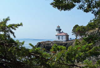
There are lots of interpretive signs by the lighthouse that make it clear that the chances of seeing a whale here are probably better than the chances of winning the lottery, but not a lot better. The last whale sighting was at 11 p.m. last night, we read on a blackboard. Then we look at a chart. Last year, orcas were only sighted here 150 times. We don't feel so bad about not seeing a whale after all. The odds were against it. But, it was a lovely place to picnic, nonetheless.


The park also features, as its name implies, the ruins of lime kilns used from the late 1800s well into the 1900s. Limestone was quarried on the island, broken into six inch diameter chunks, fed into the 1,000 degree kilns, and shoveled out the bottom as lime. To keep the fires burning took prodigious quantities of wood, and they practically denuded the whole island of trees before lime production ceased. There is little old growth forest here, but the island has recovered well.


Where conifers have not reclaimed the land, there are orchards and farms. We tasted wine at an island vineyard and winery, and stopped to admire fields in purple bloom at a lavender farm. There are fields of grazing sheep and goats, lots of horses, and even an alpaca farm (with a lone camel who probably wonders how he got here among the alpacas).


Friday Harbor, where the ferry docks, is the main town on the island, with many coffee shops and restaurants, and other lures to tourists. The bakery/espresso shop here opens at 4 a.m. to serve the early ferry, and stays open until the last ferry of the evening. We love this shop—it's where we got our coffee and pastries at 6:30 a.m. before bird watching, and where we went at night when we craved a sweet end to our day. After enjoying a pizza and a great local blues band at an Italian restaurant in town, we stopped in at the bakery for a late night fresh strawberry rhubarb cobbler.


We left the island on the 1 p.m. ferry on Saturday. Everyone told us to get there are least two hours early, because it is a popular ferry, and if it fills up, the wait for the next one is almost four hours. Once you get your car in line,
you can just leave it there, and stroll about town until boarding time.


While our car sat in the ferry queue, we enjoyed the Friday Harbor Farmer's Market that happens every Saturday. It was a wonderful opportunity to see all the products that come from the farms we passed as we drove around the island. There were fresh cut flowers, goat cheese, organic eggs, berries, herbs, honey, bread, meat and fish vendors, and baked goods, all sold on a bluff overlooking the bay and marina below.


We took a stroll around the Friday Harbor Marina before heading back to our car. We think the San Juan Islands would be a tremendous cruising ground—scenic, with many fun ports of call--akin to the Chesapeake Bay, but not as hot in the summer. Based on the huge number of beautiful boats here and at the Roche Harbor Marina on the other end of the island, there are many boaters here who would agree.


Our ferry ride back to the mainland was fog-free. We ate our lunch at a table next to a window, watching the scenery go by. There were lots of Saturday sailors, trawlers and fast boaters all around, and even a ski plane or two threading through the traffic to find a straight line for take-off.


San Juan Island has been a highlight of our journey, and we can imagine spending much longer in this area exploring the other islands in the San Juans, but we are both ready to head home now.


Eastward ho!